Exploring the Rainiest Place in the Americas: Western Colombia
Rainfall climatology and the diurnal cycle
The rainiest place in the Americas, and among the rainiest in the world, is the western part of Colombia, just south of Panama, where the western slopes of the Andes mountains face the Pacific ocean across a ~100km coastal plain. (See Map).
 |
 |
 |
 |
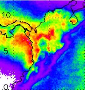
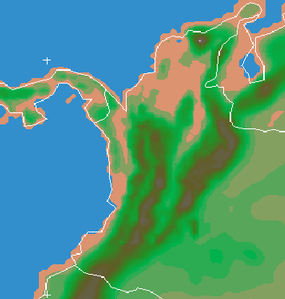
| Figure 1: Annual rainfall, year 2000 (courtesy Andy Negri of NASA). Longitude range is from 82W to 70W, latitude from 0 to 12N. | Figure 2: Terrain elevation for the same area (meters). | ||
The rain in this region has more diurnal than annual variation - that is, it varies more among the hours of the day than among the months of the year. In some places, rain falls on more than 300 days per year. The diurnal cycle has a particular pattern, shown in Fig. 3 in the form of a longitude-time section, averaged over latitudes 5-7 degrees north. The rainfall over land falls in the late afternoon and evening, at the foot of the Andes mountains. The coastal and offshore rain begins after midnight, then propagates westward over the ocean during the morning and afternoon hours. An after-midnight maximum also prevails over the Cauca Valley at longitude -75. The model simulates all these basic features of the diurnal cycle.
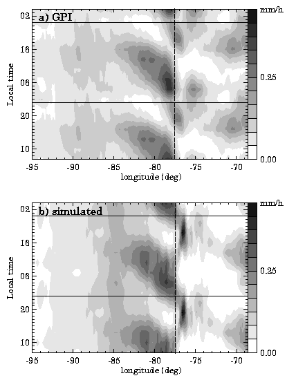 |
Figure 3: The mean diurnal cycle of rainfall rate, averaged over 5N-7N during August-September. Top: rainrate inferred from satellite data (a smeared view, based on high cloud cover). Bottom: simulated with the MM5 model at 24 km grid spacing. The diurnal cycle is repeated twice for clarity. Dashed vertical line shows the coastline. |
Understanding the Diurnal Cycle
Since the model simulated the diurnal cycle successfully, we can devise experiments to isolate the dominant physical processes in the model and feel confident that these processes are important in nature as well.
- The daytime part:
The easiest part of the diurnal cycle to understand is the afternoon. Land is heated by the sun during the day, and this heat is transferred to the boundary layer of the atmosphere, which extends up to about 1km by late afternoon. The adjacent cooler, denser air over the sea flows ashore, forming a sea breeze. At the front edge of the sea breeze, there is convergence of air and rising motion. This rising motion favors convection, especially in the late afternoon when the air over land is at its warmest. This process causes the afternoon-evening maximum of rainfall 50-100 kilometers inland.
- The nighttime part:
The sudden, strong eruption of convection offshore after midnight is more difficult to explain. It is tempting to ascribe it to a land breeze: a circulation analogous to a sea breeze, but caused by nighttime cooling of air over land. This is unsatisfying, because the cooling of land at night by emission of infrared radiation is much less intense than afternoon heating by sunlight. This is especially true in the humid tropics, because water vapor is an active absorber and emitter of infrared radiation. Furthermore, cooling a fluid (like air) from below is a very inefficient way to generate circulations. The cooling tends to create a thin, cool stable boundary layer, which does not flow very effectively over the rough land surface.
A related idea, sometimes included in the term land breeze, is a katabatic flow: cool air draining downhill under the action of gravity. Our first hypothesis was that a katabatic flow down the slopes of the Andes was responsible for the offshore convection at night. However, the katabatic flow hypothesis suffers from many of the same objections as the land breeze hypothesis. Its one advantage is that mountainsides might be expected to cool more strongly than a low, humid coastal plain.After further research, we concluded that the katabatic flow hypothesis fails to explain the offshore convection.
Convection, which produces the rainfall in this area, depends on the rising of air from near the Earth's surface to high altitudes in the atmosphere. The air rises because of buoyancy, an upward force that acts on air which is less dense than surrounding air at the same level. We calculated the buoyancy of near-surface air before and after midnight, to see what difference could explain the sudden burst of convection offshore after midnight. Figure 4 shows that a layer of negative buoyancy at about the 800 hPa level, which prevents convection in the afternoon, suddenly disappears after midnight The appearance of all-positive buoyancy and hence convection is due to a cooling of the 800 hPa temperature after midnight.
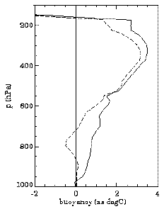
Figure 4: Buoyancy as a function of pressure (altitude) for near-surface air rising through the atmosphere at an offshore location. Dashed line: at 19 LST (7:00 p.m.). Solid line: at 01 LST (1:00 a.m.). Finally, then, we are led to ask what causes this nocturnal cooling at 800 hPa? Figure 5 shows that waves of warm and cold temperature emanate from the Andes, in response to the solar heating of the mountains, whose tops are at about the 800 hPa altitude. The speed of these waves is about 20 m/s, much faster than the wind in the lower troposphere, so the temperature is not simply blowing along, but rather is propagating as a wave. These fast-moving temperature waves are called gravity waves or buoyancy waves. Similar waves are seen in the model at other latitudes, such as near the equator, where there is no offshore convection due to the cold Pacific waters. This indicates that while the waves modulate the convection, the convection does not affect the waves strongly enough to disguise their true source: the mountains.
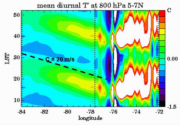
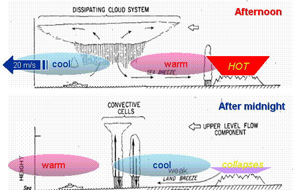
Figure 5: Temperature anomalies (T = temperature minus a mean value over the ocean) at the 800 hPa level in the atmosphere. The mean diurnal cycle is repeated twice for clarity, as in Fig. 3. Over the mountains, T is almost always positive, especially in afternoon-evening (white areas inside red contours). Waves emanate out to sea at a speed of about 20 m/s. The conceptual model summarizing our findings is shown below, adapted from Houze, Geotis, Marks and West (Monthly Weather Review 1981, page 1612). Their work was on the diurnal cycle near Borneo, but the landscape situation in Colombia is very similar. The new lesson of this work is that, although weak land breezes do exist, the more important phenomenon controlling the offshore convection after midnight is gravity waves. These waves emanate from the daily pulsation of solar heating of the elevated terrain of the Andes.