Droughts Through Time
| Shaleen Jain and Martin Hoerling NOAA/ESRL Physical Sciences Laboratory Connie Woodhouse NOAA Paleoclimatology Program |
 |
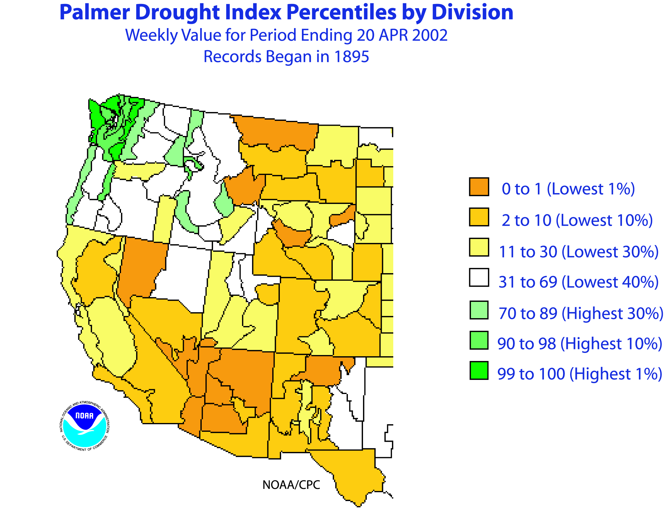 Current drought is providing yet another specter of societal vulnerability to
climatic extremes in the interior West. The potent expression of drought is being
felt across western communities and landscape-acute water shortages, early onset of
the wildfire season, and lower or no crop yields are some of the impacts in the
near-term. The severity and expansive nature of the current drought (see figure
at left), and the unusual climate of the recent past may lead one to ask the question:
"Were such persistent climatic departures a common feature of the past?" or,
"How unusual are these multiyear droughts?" While these are questions for ongoing
research and no definitive answers are readily available, a better understanding of
past climates is a key step towards a better perspective on longer-term climate and
water supply variations. In what follows, we discuss results from a recent study
that probed records of past climates.
Current drought is providing yet another specter of societal vulnerability to
climatic extremes in the interior West. The potent expression of drought is being
felt across western communities and landscape-acute water shortages, early onset of
the wildfire season, and lower or no crop yields are some of the impacts in the
near-term. The severity and expansive nature of the current drought (see figure
at left), and the unusual climate of the recent past may lead one to ask the question:
"Were such persistent climatic departures a common feature of the past?" or,
"How unusual are these multiyear droughts?" While these are questions for ongoing
research and no definitive answers are readily available, a better understanding of
past climates is a key step towards a better perspective on longer-term climate and
water supply variations. In what follows, we discuss results from a recent study
that probed records of past climates.
Multidecadal Streamflow Regimes: Middle Boulder Creek, Colorado
A recent case study of the past multidecadal streamflow regimes for Middle Boulder Creek, Colorado provided some useful results, and a starting point for potentially revisiting the drought-related planning and policy considerations in the backdrop of some new understanding of the long-term climate and water variations. In the interior West, increased demand for water coupled with the uncertain nature of anthropogenic (stemming from human influences) and natural hydroclimatic variations add challenges to the task of assessing the adequacy of the existing regional water resources systems. Current availability of relatively short instrumental streamflow records further limits the diagnosis of multidecadal and longer time variations. Based on a 285-year long tree-ring reconstruction, the analysis of the reconstructed streamflow provided useful insights for assessing regional water resources vulnerability. Some key findings were: (1) a wider range of hydrologic variations on multidecadal time scales, not seen in the instrumental record, (2) wet/dry regimes show dissimilar fluctuations across various flow thresholds, and (3) temporal changes in the flow probabilities have varied "flavors" corresponding to wet and dry regimes (or characteristic patterns) and their spatial extent.
Data and Study Region
In regions where moisture is limiting to tree growth, tree rings have been found to be useful proxies of past hydrologic variations. The Middle Boulder Creek streamflow reconstruction used in this study was generated using stepwise regression to predict mean annual streamflow from a set of moisture-sensitive Front Range tree-ring chronologies. The regression model, with four variables, explained 70% of the variance in the instrumental record for the calibration period, 1950-1980. Woodhouse [2001] details the methodology and testing for the streamflow reconstruction. The final reconstruction extends from 1703 to 1987 and indicates variations at interannual and interdecadal time scales (Figure 1).
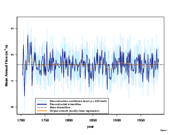 |
| Figure 1. Reconstructed water year (October-September) flows for the Middle Boulder Creek, Colorado. The 30-year smoothed estimate (based on robust locally weighted regression) shows the range of flows associated with multidecadal low (1830-1860, 1870-1900) and high (1901-1931) streamflow regimes. The increased variability in the early part of the reconstruction, from 1703-1730, in part is due to the smaller sample size as compared to the rest of the record. The confidence bands are based on the root mean squared error estimates from the verification period. |
The Middle Boulder Creek watershed is located in the South Platte River Basin. This predominantly snowmelt-driven river drainage contributes to the water supply for the City of Boulder and irrigation for local agricultural enterprises. Middle Boulder Creek mean annual streamflow is highly correlated with other South Platte Basin streams [Woodhouse, 2001], indicating a large-scale climate influence on regional streamflow, and suggesting that these results are applicable to other streams in the basin.
Multidecadal Streamflow Regimes
We use the Middle Boulder Creek streamflow reconstruction to explore multidecadal high and low flow regimes, and the extent to which water excesses and deficits are manifested across various flow thresholds (flow levels based on some key percentiles: 10%, 33%, 67%, 90%). The reconstructed streamflow shows several notable periods of persistent low streamflow during the 19th century (Figure 1). These are followed by a high streamflow period in the early 20th century that has also been noted in a number of previous studies. These persistent streamflow anomalies on multidecadal time scales provide striking examples of the wider range of natural hydroclimatic variations not seen in the late 20th century instrumental records. The anatomy of multiyear droughts is dependent not only on the mean (average) magnitude of the anomaly, but the relative frequency with which annual flow anomalies of differing severity contribute to the accumulating deficits. This is especially relevant in the context of the vulnerability assessment of the existing water resources systems - for example, the management and planning during droughts may differ based on the relative differences in the anomalous flow sequences and their associated empirical flow probabilities across various thresholds. Exploring the temporal variations in empirical probability density functions across key thresholds during multidecadal periods of low and high streamflow can provide a broader view of the level of stress exerted on the water resource management infrastructure and the numerous sectors that depend on it.
High and low streamflow regimes: Probability changes and regional hydroclimatic response
Three 31-year periods illustrating high and low streamflow regimes were examined for multidecadal time scale analysis (low: 1830-1860, 1870-1900; high: 1901-1931). These periods are noteworthy for the persistence of low and high flow, and for the fact that low flow periods of this magnitude are not found in the 20th century. Also evident are the qualitative differences in the flow sequences that constitute these three 31-year high/low streamflow periods. Indeed, if we examine the empirical probability density functions (pdf) for these flow regimes, significant differences are seen in the tail probabilities (Figure 2). Using the full record (1703-1987) as the baseline, we find that the two low-streamflow periods have heavier left limbs, confirming the temporal shift towards higher probabilities for low flows. However, the low flow regimes differ in the manner with which low flow probabilities redistribute within the 31-year periods. During 1870-1900, the flow variations were marked by an overall pdf shift towards low flows, with enhanced probabilities associated with the left limb of the pdf. In contrast, the 1830-1860 period was characterized by an increase in the more severe low flows, but with only slightly lower average flows than the full record. This suggests an increased variance in the flow and a non-uniform shift in the flow probabilities across different thresholds. The pdf for the wet period (1901-1931) shows a shift towards higher flows and heavier right limbs of the regime pdf. Again, only a part of the pdf (i.e., high flow probabilities) is outside the baseline variability band.
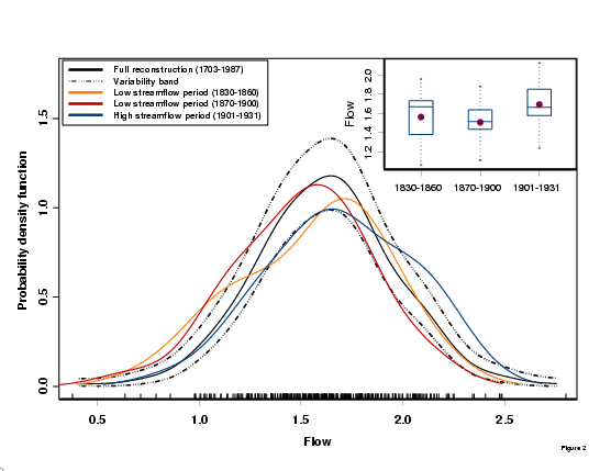 |
| Figure 2.Comparison of the empirical probability density functions for the wet and dry regimes seen in the reconstructed Middle Boulder Creek streamflow. The dashed lines correspond to the variability bands quantifying the inherent variability associated with the density estimation; the density estimation is based on optimal normal bandwidth. The three regimes show anomalously heavy tails (at different flow thresholds). (inset) The boxplots show the relative range of variations for the three regimes. The boxes correspond to the 33rd, 50th, and 67th percentile. The whiskers extend to cover the 10th and 90th percentile. Mean flow during the low and high streamflow regimes are shown by red dots. |
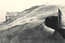
The longer-term perspective on streamflow excesses and deficits reflects the regional expression of climate variations and change. Although no mechanistic explanation for the past climate variations and change is proffered, it is useful to examine the spatial scales associated with the multidecadal flow variations. Figure 3 shows the Palmer Drought Severity Index (PDSI) [Cook et al., 1999] anomalies for the three low and high flow regimes discussed above. On these multidecadal averaging scales, there appears to be a remarkable degree of spatial coherence during the 1901-1931 wet period. Similarly, the 1870-1900 dry period shows a southwest US drought extending to the intermontane and central US region. The 1830-1860 dry period is characterized by a higher variability (see Figure 2, inset). Wet in some years, it also contains the most persistent and intense low flow period (mid-1840s through the late 1850s) in the full 285-year record. Although, the dry conditions were extensive in some of these years (1842, 1845-47, 1855-56), persistent drought conditions were restricted in spatial extent, with a core area in eastern Colorado [Woodhouse et al., 2001]. This observation of a dry period is also supported by the limited documentary evidence of increased eolian sand dune movements (most likely related to drought and high temperatures) from the 1840-1870 period over the western Great Plains [Muhs and Holliday, 1995]. The composite PDSI (Figure 3) for 1830-1860 period indicates the less widespread nature of this dry period, with an extension of dry conditions into parts of the Great Plains. Overall, it seems clear that persistent and severe droughts have been a feature of the 19th century. This evidence provides a compelling perspective for reassessing the adequacy of current water resource management and planning infrastructure.
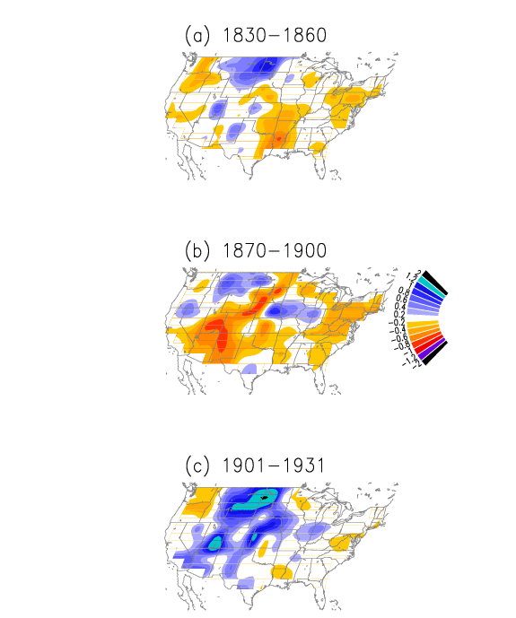 |
Figure 3. Composite PDSI anomalies corresponding to the diagnosed multidecadal streamflow regimes. The 1700-1978 PDSI reconstruction used here is based on 154 grids spanning the conterminous United States [Cook et al., 1999]. For the Colorado region, the mean and standard deviations for the three period are noted in the parenthesis: 1830-1860 (-0.07, 1.8), 1870-1900 (-0.61, 1.4), and 1901-1931 (0.352, 1.44). Note that the highly localized PDSI anomalies exceeding a magnitude of 1.2 are shown using a single color code. |
Concluding Remarks
The regional vulnerability to climate and water supply variations stems from: (a) the variable and uncertain nature of water supply, primarily stemming from hydroclimatic variations and change, and (b) the rapidly evolving nature of regional water demand, due to population growth, recreation needs, hydropower, agriculture, and mandatory water allocation for stream and riparian ecosystems. The results presented here provide a long-term perspective for climate-related vulnerability, with relevance to a number of emerging drought-related vulnerability issues:
The analysis of a long streamflow record showed that the reliability of water supply is contingent upon the nature of hydrologic regime. On water resources planning and management time horizons (typically 30-50 years), an understanding of multidecadal streamflow variations is necessary to devise robust planning and operations strategies. Furthermore, the temporal changes in flow probabilities are threshold-sensitive--the severity of the multidecadal flow excesses and deficits are thus quite sensitive to the different "flavors" of the low and high flow regimes.
Analysis of the 19th century streamflow variations suggests the occurrence of severe and persistent droughts. In the future, such flow deficits coupled with present and future levels of water demands may inflict significant stress on the water-dependent sectors. Also noteworthy are the spatial scales of the 19th century droughts. For example, the very broad regional scale of the 1870-1900 low flow period may raise concerns over the efficacy of mechanisms such as interbasin water transfers to alleviate water shortages. In view of the observed nature of multidecadal hydrologic variability, innovative adaptive strategies must reassess management practices and hedging strategies that consider the temporal variations in climate and hydrologic risk.
- References:
- Cook, E. R., D. M. Meko, D. W. Stahle, and M. K. Cleaveland, Drought Reconstructions for the Continental United States. J. Climate, 12, 4, 11451162, 1999.
- Jain, S., C. A. Woodhouse, and M. P. Hoerling, 2002: Multidecadal streamflow regimes in the interior western United States: Implications for the vulnerability of water resources, Geophysical Research Letters, 29(21), 4 pp.
- Muhs, D. R., and V. T. Holliday, Evidence of Active Dune Sand on the Great Plains in the 19th Century from Accounts of Early Explorers. Quaternary Research, 43, 198-208, 1995.
- Woodhouse, C. A., A Tree-Ring Reconstruction of Streamflow for the Colorado Front Range. J. American Water Resources Association, 37, 3, 561-570, 2001.