Snow-Level Radar
Snow level, the altitude in the atmosphere where snow changes into rain, is a critical parameter influencing runoff in mountainous watersheds because it determines the surface area of the watershed that will be exposed to rain versus snow. When the snow level is above most or all of the terrain in a watershed, a storm is more likely to produce enough rapid runoff to cause flooding. If the snow level is low in a watershed, then a storm increases the snowpack, providing valuable storage of water for potential later use.
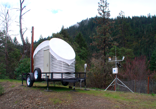
Staff at the Physical Sciences Laboratory (PSL) designed, built, and deployed a new network of snow-level radars, which are being used in California. The radar was designed specifically as part of a project with the California Department of Water Resources (CA-DWR) to provide a cutting-edge system to help address water resource and flood control concerns. This project applies lessons learned from almost two decades of research on West Coast winter storms conducted by researchers in NOAA's Hydrometeorology Testbed (HMT), including the first-ever evaluations of operational snow-level forecasts that used an earlier generation of radar technology.
The snow-level radar uses a modernized frequency-modulated, continuous wave (FM-CW) technology, which uses less than a watt of transmitted power. This dramatically reduces the price of the radar components. The snow-level radar can be built for approximately 1/5th of the price of one of the current state-of-the-art pulsed radars used for the same purpose. The radar operates at 2.835 GHz, which is ideal for measuring the properties of precipitation because at this frequency there is very little weakening of the radar signals by precipitation. Snow-level detection is based on a patented automated algorithm developed by CIRES and NOAA scientists.
A five-year agreement with CA-DWR has resulted in ten semi-permanent snow-level radar deployments in key watersheds across the state. The radars are part of an unprecedented observing network that will provide critical information on the forcings of extreme precipitation and flooding, as well as long-term climate observations to help decision makers adapt to a changing climate.