El Niño Rapid Response Field Campaign, preliminary research findings, and five resulting datasets

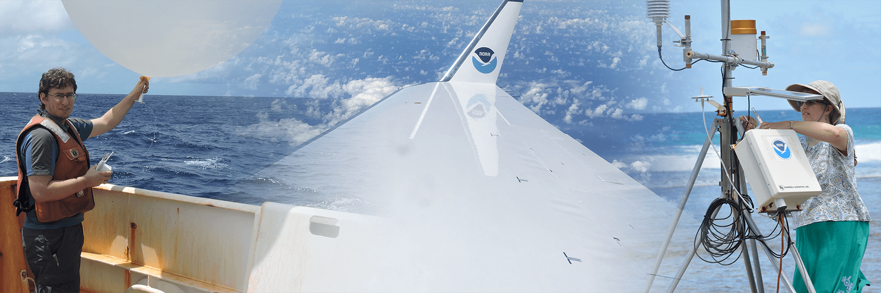
Photos from the ship, air, and ground during ENRR 2016.
El Niño influences weather around the world. Some regions experience warmer and drier than
average temperatures, while other areas are wetter and cooler than average. El Niños can produce
extreme precipitation events that threaten life and property.
During an especially strong El Niño event in 2016, scientists at NOAA embarked on a rapid-response land, sea, and
airborne study—the El Niño Rapid Response (ENRR)
field campaign—to better observe and understand the initial
response of the atmosphere to El Niño sea surface temperatures impacting U.S. weather.
In the May issue of the Bulletin of the American Meteorological Society, researchers from ESRL's
Physical Sciences Laboratory (PSL) and collaborators describe this unprecedented research effort to
collect a unique portfolio of observations during a strong El Niño event. From the tropical Pacific to the U.S.
West Coast, instruments were deployed in the air from NOAA's Gulfstream IV aircraft and NASA's
Global Hawk Unmanned Aircraft, from the ocean onboard the NOAA ship Ronald H. Brown, and on land
in California and the central equatorial Pacific island of Kiritimati. These measurements of ocean and atmosphere interactions
will help scientists better understand the chain of events that produces, among many
weather impacts, extreme precipitation on the U.S. West Coast.

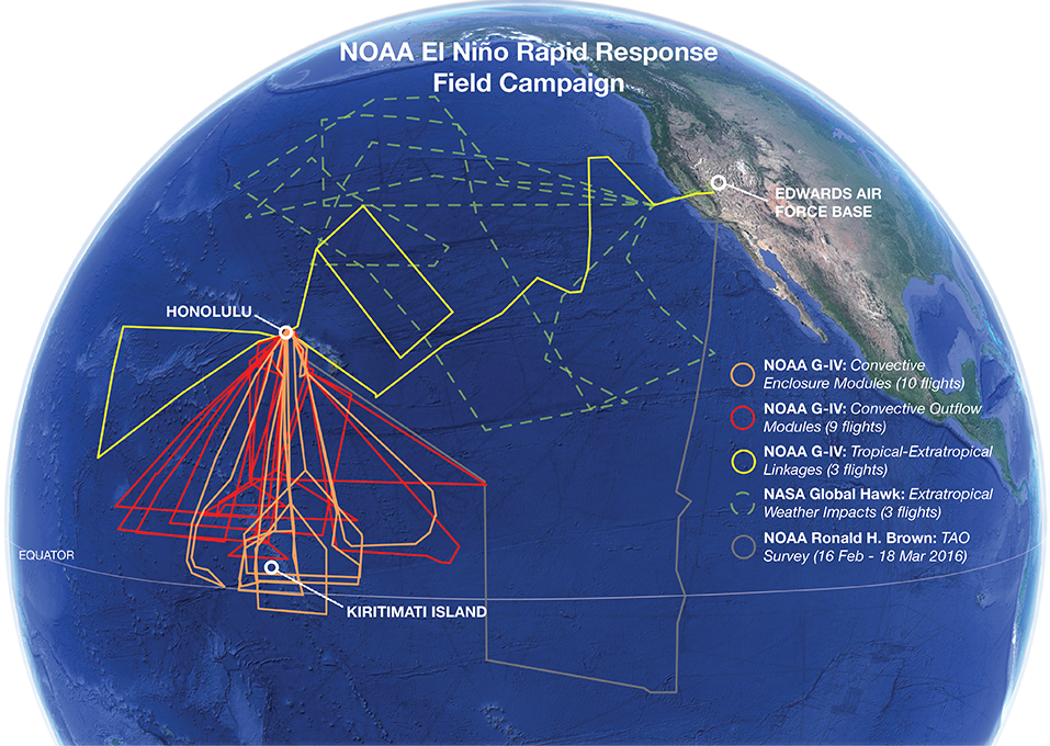
Overview of ENRR field campaign coverage by observational platform.
Overview of ENRR field campaign coverage by observational platform.
In addition to describing the campaign planning and implementation, and the observations collected,
the paper presents preliminary assessments of ENRR dropsonde data relative to satellite observations and NOAA Global Forecast System (GFS) output,
the impact of ENRR observations on GFS analyses and forecasts, and the impact of ENRR
observations on NASA Goddard Earth Observing System (GEOS) model forecasts during the field
campaign.
Two articles have also been published in the June issue of Earth System Science Data
documenting five ENRR data sets from Kiritimati Island and the NOAA ship Ronald H. Brown. The
data include surface meteorology, surface [air-sea] fluxes, and observations of winds,
temperatures, and humidity in the lower 25 km of the atmosphere. These data have been archived,
together with extensive metadata, at NOAA's National Centers for Environmental Information and
are free for public access.
Documentation of the design, planning and implementation of ENRR illustrates that a rapid response
field campaign using multiple observing platforms to study a quickly
evolving extreme climate event (such as El Niño) is feasible and can provide valuable
contributions to advancing both science and services. Future responses could be enhanced through
preplanning response options and identifying coordination opportunities for specific phenomena
or events.
ENRR data and the resulting observation-based process understanding will combine to help improve models that are used to support weather forecasts.
The resulting research will also provide insights that can be used to improve year-to-year ENSO forecasts, as
well as the accuracy of weather forecast models used to predict subseasonal to seasonal extreme
events and their impacts.
Posted: July 2, 2018
El Niño influences weather around the world. Some regions experience warmer and drier than
average temperatures, while other areas are wetter and cooler than average. El Niños can produce
extreme precipitation events that threaten life and property.
During an especially strong El Niño event in 2016, scientists at NOAA embarked on a rapid-response land, sea, and
airborne study—the El Niño Rapid Response (ENRR)
field campaign—to better observe and understand the initial
response of the atmosphere to El Niño sea surface temperatures impacting U.S. weather.
In the May issue of the Bulletin of the American Meteorological Society, researchers from ESRL's
Physical Sciences Laboratory (PSL) and collaborators describe this unprecedented research effort to
collect a unique portfolio of observations during a strong El Niño event. From the tropical Pacific to the U.S.
West Coast, instruments were deployed in the air from NOAA's Gulfstream IV aircraft and NASA's
Global Hawk Unmanned Aircraft, from the ocean onboard the NOAA ship Ronald H. Brown, and on land
in California and the central equatorial Pacific island of Kiritimati. These measurements of ocean and atmosphere interactions
will help scientists better understand the chain of events that produces, among many
weather impacts, extreme precipitation on the U.S. West Coast.

Overview of ENRR field campaign coverage by observational platform.
Overview of ENRR field campaign coverage by observational platform.
In addition to describing the campaign planning and implementation, and the observations collected,
the paper presents preliminary assessments of ENRR dropsonde data relative to satellite observations and NOAA Global Forecast System (GFS) output,
the impact of ENRR observations on GFS analyses and forecasts, and the impact of ENRR
observations on NASA Goddard Earth Observing System (GEOS) model forecasts during the field
campaign.
Two articles have also been published in the June issue of Earth System Science Data
documenting five ENRR data sets from Kiritimati Island and the NOAA ship Ronald H. Brown. The
data include surface meteorology, surface [air-sea] fluxes, and observations of winds,
temperatures, and humidity in the lower 25 km of the atmosphere. These data have been archived,
together with extensive metadata, at NOAA's National Centers for Environmental Information and
are free for public access.
Documentation of the design, planning and implementation of ENRR illustrates that a rapid response
field campaign using multiple observing platforms to study a quickly
evolving extreme climate event (such as El Niño) is feasible and can provide valuable
contributions to advancing both science and services. Future responses could be enhanced through
preplanning response options and identifying coordination opportunities for specific phenomena
or events.
ENRR data and the resulting observation-based process understanding will combine to help improve models that are used to support weather forecasts.
The resulting research will also provide insights that can be used to improve year-to-year ENSO forecasts, as
well as the accuracy of weather forecast models used to predict subseasonal to seasonal extreme
events and their impacts.
Posted: July 2, 2018

