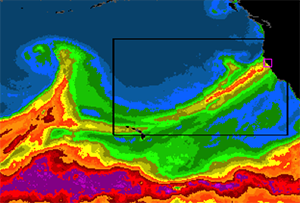
Atmospheric River: December 11, 2014
|
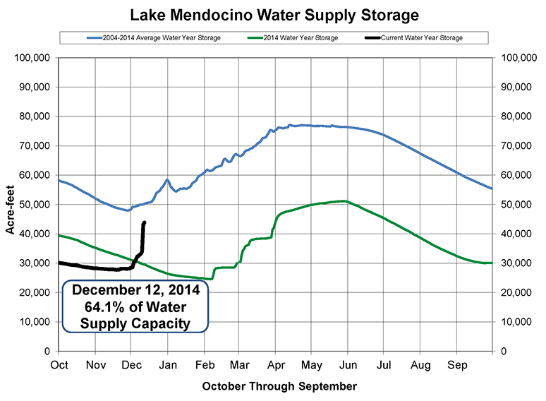
Lake Mendocino Water Supply Storage: Black curve is the added storage supplied by two atmospheric river storms in December, including the event this week. Blue line is the average storage over the past 11 years. Green curve is storage from 2014 during a severe 2-year drought. (Credit: Sonomoa County Water Agency)
|
Scientists use Major West Coast Winter Storm to Prepare for Upcoming Field Experiment
December 12, 2014
As widespread rain and snow began falling across California this week, researchers from the NOAA/ESRL Physical Sciences Laboratory (PSL) and their colleagues were in the midst of a detailed ‘dry run’ in preparation for a major field experiment to study similar high-impact winter storms.
The CalWater 2015 begins in mid-January when several research aircraft converge in California for the two-month study, which will examine how intense moisture-bearing storms (called atmospheric rivers) and long-range transported dust and pollution affect precipitation over the varied terrain of the West Coast. During the same period, the NOAA Research Vessel Ronald H. Brown will sail from Hawaii to a region off the California coast so scientists can study the interaction between the ocean and atmosphere, and how it influences atmospheric rivers. The combined aircraft and shipboard measurements will help researchers to understand the scientific ingredients that contribute to atmospheric rivers.
For this week’s dry run, forecasters presented and discussed short to long-term weather, and dust and pollution forecasts. Lead flight and mission scientists then used the forecast information to develop flight plans and coordinate ground and ship operations for the next day. What planners of this event didn’t realize six months ago was that a major winter storm would coincide with the dry run.
“Mother Nature delivered the ideal storm to exercise and refine our operations and implementation skills,” says Flight Operations Scientist, Ryan Spackman of PSL. “It will help prepare us for how to best execute the real mission this winter.”
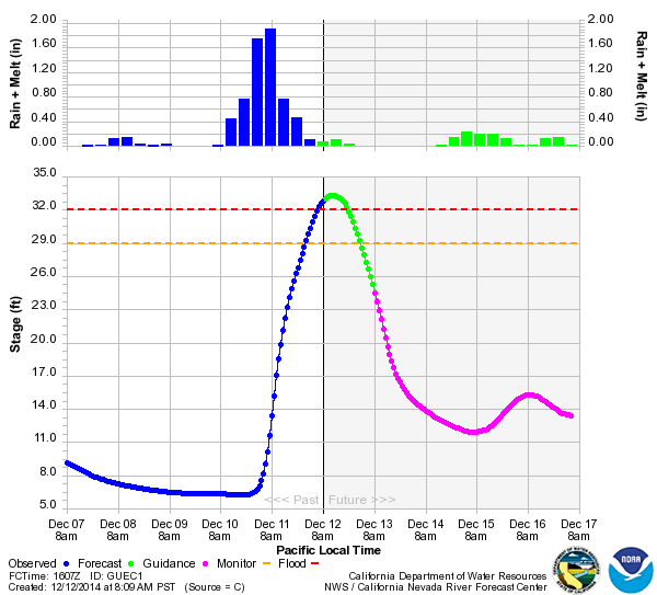
Russian River at Guerneville, CA: Blue bars (top left) show 6-hour precipitation accumulations. Blue curve (bottom left) shows river level. Green bars (top right) show 6-hour precipitation accumulation forecast. Green and pink lines (bottom right) are forecasts of river level for the next 5 days. Levels above the red dashed line indicate flooding.
|
While this was an important practice exercise for the CalWater researchers, it was a real-world experience for weather and river forecasters, emergency and water resource managers, and the general public. Fortunately for all parties involved, the forecasts for this event were on target.
“The weather forecasts for this winter storm and associated landfall of the atmospheric river were fantastic,” says CalWater meteorologist Jay Cordeira of Plymouth State University. “They suggested a high-impact event for California more than 5 days in advance. This storm and these forecasts gave us the perfect opportunity to field test several new forecast diagnostics for use in CalWater."
This recent atmospheric river brought some relief to one of the worst two-year California droughts on record. For example, Lake Mendocino, one of two vital reservoirs on the Russian River north of San Francisco, made a remarkable storage recovery from this storm. This partly was due to the fact that previous rainfall in November and December helped recharge the soils and ground water such that much of the rainfall from this week’s event produced runoff into the reservoir. Unfortunately, the large volume of unimpeded water flowing into basins like this one across the West Coast states created moderate to severe flooding in some communities, including the town of Guerneville on the Russian River.
“That’s why we’re studying these sometimes dangerous storms,” says Spackman. “With better understanding of the structure and evolution of atmospheric rivers, we can improve forecasts and better prepare communities."
- Ryan Spackman, Researcher, 303.497.7873
- Chris Fairall, Researcher, 303.497.3253
- Allen White, Researcher, 303.497.5155
- Barb DeLuisi, Communications, 303.497.4233